Business Details
18 Years
experience
Professional Aerial Photography Services
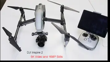
Founded in 2008, Above All Photography has established itself as the leading aerial photography and video provider in the Midwest. Our team combines cutting-edge technology with decades of expertise in aerial imaging, piloting, and post-production to deliver high-quality visual solutions for commercial clients. We operate three independently managed locations, maintaining rigorous standards to ensure consistency and excellence across all projects. Our services span aerial photography, drone operations, 3D compositing, architectural imaging, and precision mapping using FAA-authorized equipment.With a fleet including the DJI Inspire 2 drone and Cessna 206 aircraft, we handle complex assignments nationwide while guaranteeing timely delivery and 100% client satisfaction. Our in-house capabilities include broadcast-quality video stabilization, georectification, and graphic design integration, serving industries ranging from real estate development to civil engineering. As a federally trademarked company, we prioritize innovation through continuous investment in advanced imaging systems and professional training for our certified pilots and photographers.
Services
Aerial Photography
Drone Photography
Aerial Video
3D Compositing
Architectural Photography
Interior Photography
HDR Imaging
Video Stabilization
Graphic Design
Precision Mapping
Details
- Year established: 2008
Highlights and features
- We offer FAA-authorized drone operations with wide-area permissions near Indianapolis International Airport
- Our team includes instrument-rated commercial pilots with over 2,500 flight hours
- We utilize true aerial survey cameras for 6-pixel resolution georectified mapping
- Our 3D compositing workflow integrates aerial footage with Autodesk 3D Studio Max
- We maintain broadcast-quality video equipment with Kenyon Laboratories gyro stabilization
Services
Aerial Photography
Our aerial photography services capture high-resolution images using FAA-authorized drones and manned aircraft. We provide oblique, vertical, and HDR imaging options with precision georectification for commercial applications. Clients receive professionally processed images suitable for real estate marketing, construction documentation, and environmental surveys.
3D Compositing
This service combines aerial footage with 3D modeling to create photorealistic visualizations. Using Autodesk 3D Studio Max and Syntheyes camera tracking, we produce accurate architectural renderings and construction simulations. Clients benefit from enhanced project presentations that integrate aerial perspectives with proposed design elements.
Precision Mapping
Our precision mapping service utilizes specialized aerial survey cameras and GPS equipment to create accurate planimetric maps. The 6-pixel resolution imaging system captures detailed topographic data for land development, infrastructure planning, and environmental monitoring applications across multiple states.
Aerial Video
We provide stabilized aerial video production using broadcast-quality Panasonic HDX-900 cameras and Kenyon Laboratories gyro systems. Our helicopter and airplane platforms capture smooth footage for media production, marketing materials, and engineering documentation with post-stabilization processing available.
Architectural Photography
This service offers professional architectural photography with both aerial and ground-based perspectives. We use specialized equipment to maintain vertical line integrity and proper lighting balance for commercial properties, residential developments, and interior spaces across the Midwest region.
People
James Grumme
Owner / Photographer / Pilot
Indiana University graduate with 2,500+ flight hours, specializing in aerial imaging and 3D visualization. Manages mapping projects and website development while operating as lead pilot and photographer.
Jay Grumme
Client Services
Handles client communications and project coordination, ensuring timely delivery of aerial photography services while maintaining quality standards across all assignments.
Questions
What areas do you service for aerial photography?
We cover the Midwest region with primary locations in Indianapolis, St. Louis, and Cleveland. Our services extend nationwide for multi-state projects and special assignments.
What equipment do you use for aerial imaging?
We use DJI Inspire 2 drones, Cessna 206 aircraft, and Robinson R-44 helicopters equipped with broadcast-quality cameras and stabilization systems for professional aerial capture.
Can you handle large-scale mapping projects?
Yes, our precision mapping capabilities include georectification and 3D compositing for large areas using specialized aerial survey equipment and GPS navigation systems.
Do you offer video stabilization services?
We provide post-production stabilization for aerial footage using professional software tools to ensure smooth, broadcast-ready video output for our clients.
What industries do you typically work with?
We serve commercial real estate, construction, civil engineering, media production, and economic development sectors requiring professional aerial imaging solutions.
Are your pilots FAA certified?
Our lead pilot holds instrument-rated commercial certifications with over 2,500 flight hours and we maintain FAA authorization for drone operations in restricted airspace.
Videos